Showing posts with label earthquake. Show all posts

Tuesday, April 1, 2014

Chile's Thrust Fault- 8.2 Magnitude Earthquake

Hello Bloggers,

I sadly report that an 8.2 magnitude earthquake has struck the coast of Chile, prompting evacuations and tsunami warnings.  At 5:04pm Pacific Standard Time, a quake from the San Ramon thrust fault line resulted in at least one initial small tsunami of about 6 feet.

This fault line, which is a thrust fault line much like the one that caused the 2011 Tohoku tsunamis, is quite active and has caused a range of quakes from mild to severe in the last few decades.

A tsunami alert has been issued for Chile, Ecuador and Peru, and all coastal areas are being evacuated as best as possible. 

More soon.  For information on thrust faults and other fault lines, visit these blog posts:
http://www.oregonbeachcomber.com/2012/09/historic-events-will-history-repeat.html
http://www.oregonbeachcomber.com/2013/01/false-warning-and-dock-clean-up.html

A thrust faultline forces a wall of water upwards and towards shore. Sciencythoughts.blogspot.com

Monday, December 9, 2013

It was long, and strong, and scientists are down to get their friction on (in the 2011 Tohoku Quake)

Okay, how could you not think of Sir Mix-A-Lot's 'Baby Got Back' when you hear about this topic?  At least, I couldn't. 

In a news release from Oregon State University this month, an international team of scientists (including faculty from OSU's College of Earth, Ocean, and Atmospheric Sciences) have taken a look at the amount of friction generated in the 2011 Tohoku Earthquake.  Why?  To take a measure of how 'slippery' the fault is.

This was done in a groundbreaking and unique way- by drilling through 800 meters of the seafloor to place specialized temperature data loggers in the fault area.  Scientists can translate measures of heat into friction- think of rubbing your hands together quickly; the friction, or action of two surfaces moving against one another- create heat.  The same is true for the earth's tectonic plates rubbing against one another, but on a much larger scale.  More heat means more friction, or energy generated when the plates rub together.  Less heat means the faults slide more easily past one another.

http://www.robinage.com/article-images/friction.jpg
Imagine this, on tectonic plate scale.

Turns out, these plates (The large Pacific Plate and more regional Okhotsk plate, on which much of Japan rests) slide pretty easily by one another.  This means that there is little resistance for subduction of the Pacific Plate under its neighbor.  What does this mean? That it may take a lot less to generate plate movement, and therefore earthquakes, than previously thought.

http://earthquake.usgs.gov/earthquakes/world/japan/Japan-TohokuM9.0EQ-Mar11_2011_prelim_geodetic_slip_Figures/backg.jpg
These are some slippery plates. (Image: USGS)

Oh, and to specify what 'little' resistance means in tectonic scale terms; The quake generated approximately 27 million joules in two minutes, which is a lot.

Just for comparison's sake, a hamster in a wheel can generate a mere ~60 J in two minutes' time; that is, it would take 720,000 hamsters running in wheels to generate that much energy.

http://christinekane.com/wp-content/uploads/2008/06/hamster2.jpg
Wow.
Check out OSU's article here, or keep an eye out in Science later this week for the peer-reviewed study, which I hope is called 'Baby got Back (Calculated)'.

Friday, October 25, 2013

Fukushima issued with small tsunami alert

The USGS has just reported that a 7.1 magnitude earthquake off the coast of Fukushima (at about 10 km depth).  The quake has resulted in the administration of a tsunami warning; this time much smaller than the version that struck the coast in 2011.  Today's earthquake was a normal slip-strike quake rather than the devastating megathrust variety, resulting in a much smaller (3.0 feet) lifting of the oceans being predicted.

However, these small tsunami effects can still be dangerous for those in low-lying coastal areas; a bystander was swept out to sea in 2011 in Crescent City, California when he and his friends went down to photograph the incoming waves from the Japan earthquake.

Remember, if you are in the zone of a tsunami warning- no matter how small- stay to higher ground and resist the urge to watch from unsafe locations.

To keep up on recent earthquakes, visit the USGS's Earthquakes Page- you might be surprised how common they are!

Tuesday, January 8, 2013

All Cleaned Up and Nowhere to Go


Happy New Year to you, readers!

The first week of 2013 has brought about some interesting marine-related developments that are worth blogging about!

MINOR QUAKE
At midnight on January 5th, a magnitude 7.5 earthquake struck offshore southwest of Juneau, Alaska, prompting several tsunami warnings as further information was gathered about the quake.   While the quake caused a small amount of damage inshore, the tsunami warning was quickly canceled an hour later, as water levels barely rose 1 foot above normal tidal level.  This is due to the tectonics of the earthquake, which was a slip-strike quake- a form of earthquake where two tectonic plates slide past each other horizontally, creating an earthquake but not much potential for an uplifting of water.  The worst tsunamis are generally created by megathrust or reverse fault quakes, where one portion of the Earth's crust is abruptly uplifted, forcefully moving the water column.  The force of this propagates outwardly in a wave pattern, eventually hitting surrounding shores.

The 2011 tsunamis were caused by a megathrust earthquake.

A small earthquake struck again near Juneau this morning (January 8th) with a magnitude of 4.0 near the same epicenter.


Normal, Reverse (megathrust) and Slipe-Strike faults. [Image: South Caroline Department of Natural Resources]


Simulated tsunami wave of a possible 8.0 Cascadia earthquake.  Note the outward propagation from the source, typical of most quake-generated waves. [modernsurvivalblog.com]

DOCK CLEAN UP
Further down the eastern Pacific shoreline, officials in Washington have finally been able to reach the dock that washed up on a La Push beach (See last week's post).  Removal efforts have yet been planned, but much like the dock that washed up on Agate Beach, OR, biological contaminants were a priority until removal efforts can take place. 

Like the Newport dock, animal and plant life was removed with scouring, scraping, burning and cataloging more than 400 pounds of organic material, including up to 50 species native to Japan.

Dock 4
Dock awash on La Push, WA beach.  The dock is almost identical to the one that washed ashore in Newport, OR. [kxro.wordpress.com]
Unlike the Newport, OR dock, this one is quite inaccessible for removal crews, and the area has been temporarily closed off to the public.  The dock was only reached by crews traveling miles of logging roads, trails, and shoreline (kxro.wordpress.com).  Solid cement and re-bar, this dock will likely have to be removed by boat, as vehicles are not a likely option at this point.

Until then, it will sit as a reminder of ecological difficulties yet to come.


Monday, September 24, 2012

Tsunami Preparedness

Hello bloggers- greetings from the Oregon coast!

My last post discussed the inherent dangers of living in the 'Ring of Fire' - the most tectonically active region of the world.  Hopefully you weren't all scared away by the whole theme of natural disasters last time, but those of you who are still with me will get to read a much more hopeful post today!

Now that you are all informed about the inherent risks of living and working near the beautiful Pacific Ocean, I thought it would be quite relevant to discuss what is being done to prepare for possible tsunamis, as well as what you can do in the case that you find yourself here during such an event.

Oregonians do not take the threat of a possible tsunami lightly.  Anyone that has traveled here has no doubt noticed the 'Tsunami Evacuation Route' and 'Tsunami Hazard Zone' signs all along Highway 101 and throughout town.

Tsunami Hazard Zone sign off Hwy 101

The signs have grown into something iconic. Despite initial concerns that they might scare off weak-hearted tourists, they have in fact turned into a bit of a tourist attraction in themselves. The signs were initially developed via a Sea Grant project for Oregon only.  However, the signs have caught on globally and now can be seen in various countries including Chile, Mexico, Japan, and Thailand.  These are placed in low-lying coastal areas and alert people of possible danger.  Other signs entitled 'Leaving Tsunami Hazard Zone' tell folks that they are leaving danger areas. 

Much is being done to prepare for potential natural disasters, and provide public resources.  For starters, NANOOS (National Association of Networked Ocean Observing Systems) has a fairly comprehensive database and website regarding tsunami hazards.  Their main tsunami map has an excellent map with warnings, advisories, and real-time info on earthquakes.  Their map shows those zones that will be in danger during a distant earthquake (orange) and also those zones that will be in immediate danger during a Cascadia earthquake. The map has been completed for Oregon but no further as of yet.  To see if your house or place of work is in a danger zone, type in your address.  You can also use this to plan an evacuation route.  Remember that a distant earthquake will generate a tsunami in a matter of hours, and a Cascadia earthquake will take minutes to generate a wave.

The other resources on NANOOS' page include Preparedness, Warnings, Evacuation, Facts, and Travel/Propagation Time.  NANOOS recommends that you are familiar with your local evacation route, and have an emergency kit ready.  Also be familiar with impending signs of a tsunami, including a strong local earthquake (which could produce a tsunami in a matter of minutes), receding water, and the loud sound of an oncoming wave.  Much like tornadoes, witnesses have described the roar of a tsunami to that of a train.

NANOOS also has a free downloadable App (TsunamiEvac-NW) for your smartphone.

Another useful resource for tsunami information is NOAA's West Coast and Alaska Warning Center.

NANOOS' simple evacuation guide; Orange zone indicates far-away earthquake danger; Yellow zone indicates local Cascadia earthquake danger zone.

In addition to this research, OSU's O.H. Hinsdale's Wave Research Laboratory has done numerous tsunami simulations and created several models of tsunamis.  The most famous is of Seaside, Oregon, where a simulated local tsunami tore through the beach town (or a scale model of it) and gave researchers a better idea of how coastal communities could be affected.  If you haven't heard of the lab or seen the video, I'd recommend checking out their website.  They have some interesting photos and information, as well as live webcams of the wave pools (the largest in the world!).

You can see the video of little Seaside being deluged here.

Now remember that this is all just a factor of probability and chance, and there is a possibility that nothing will occur in our lifetimes.  However, we are lucky enough to have such technology and knowledge on our side. With a little planning and advance research you can familiarize yourself with your tsunami risk, and arrange an evacuation route.  Local communities regularly perform evacuation drills - one was just run last Saturday in Tillamook County- and it is a good idea to participate in these.  Additionally, your business or organization may ran drills periodically.

Keep in mind that most communities also have Tsunami warning sirens as well.  These are tested regularly, so keep tuned in to your local news for notices.

Most of all- don't worry, just be proactive!  There is nothing we can do to prevent a tsunami or earthquake from actually happening, including worrying about it. Instead, don't hesitate to prepare yourself and your family for the case of a natural disaster- including tsunamis- and do what you can to stay informed and involved in your local community.  Anywhere you live has inherent dangers- be it earthquakes, floods, tornadoes or tectonic activity- so you may as well live somewhere you love!

I love the Oregon Coast, impending waves and all.

***To all interested: The Red Cross will be hosting a Tsunami Evacuation and Preparedness session open to the public at the Hatfield Marine Science Center's visitor center auditorium (Newport, Oregon) on October 26th from 2:30 to 4pm.

Note: The views and content choices expressed in this blog are mine alone.  I am writing out of personal interest and a desire to share information with others in an accessible and fun way.  Enjoy!

Friday, September 14, 2012

Historic Events - Will history repeat itself? Part I


Greetings faithful readers!  Perhaps it is due to my recent trip to an active volcano, Mt. St. Helens, but I felt it would be good to address some geology in today's post. We will be embarking on some shaky ground, so to speak.  It has long been known (and quickly forgotten) that earthquakes have regularly occurred on the Pacific coast of North America.  From pre-history, up to only decades ago, the coasts of Oregon, Washington, northern California and Alaska have been at the mercy of the temperamental Cascadia fault.

What is the Cascadia fault? It is a product of plate tectonics, one of the primary causes of earthquakes, and volcanic activity across the globe.  For those of us who don't remember all of our geology (I know I didn't), the earth's surface is made up of a series of different zones that compose its surface.

A simple diagram of the earth's surface and core. The lithosphere- the uppermost layers of the earth's surface- are what cause tectonic activity to occur.


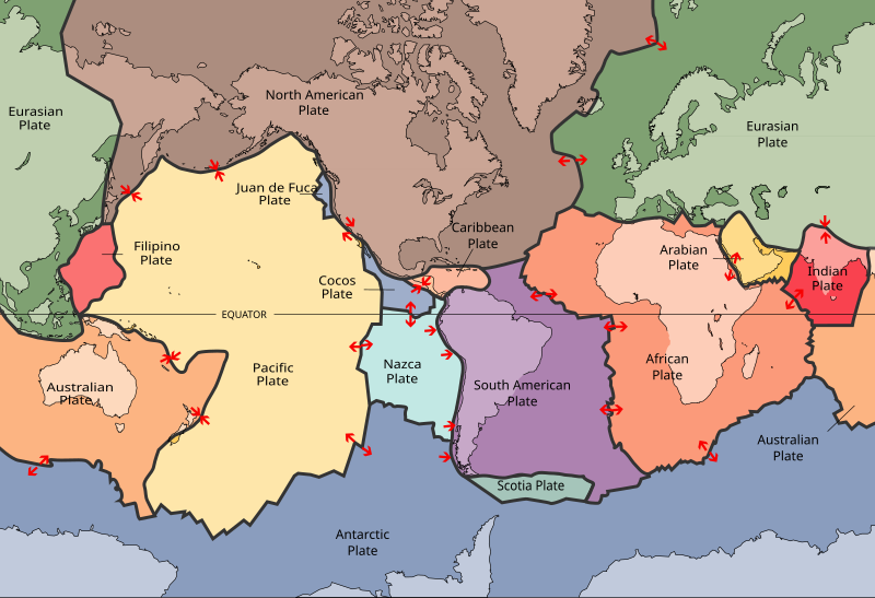
The very upper layer, called the lithosphere, is what we most often think of as the earth's surface.  It is composed of the crust and the uppermost part of the mantle.  It is also incredibly thin when considering the earth's diameter as a whole. Because our earth's lithosphere is less dense than the asthenosphere found below it, it tends to float dynamically on top of it.  The lithosphere can be divided into a series of tectonic plates- seven or eight relatively large, and several small.  The total number is still somewhat under debate.

File:Plates tect2 en.svg
A diagram of the earth's lithospheric plates as generally decided by the USGS. Arrows indicate ongoing motion. [Diagram: http://pubs.usgs.gov/publications/text/slabs.html]

The plates are always slightly moving in generally consistent directions, as shown above.  Plates moving together are creating mountains and ocean ridges- this is known as convergence.  Plates moving apart are diverging- this can form features such as ocean trenches. The last type- transformative faults, neither create nor destroy, and are usually joined with one of the other two types of faults.

In the case of our Cascadia fault, the North American Continental Plate (brown, above) is in fact overriding the Juan de Fuca plate (essentially the oceanic crust), shoving it under in a process called subduction.  As a result, we have a very nice cascade mountain range with many amazing volcanic and mountainous features along it.  This zone is approximately seven hundred miles long, and stretches from northern California onto Alaska.

http://maydamedia.com/Images/Chapter17/Map17.1.jpg
The thirteen volcanic giants of the Cascadia mountain range/faultline.  In reality, there are more than 120 of these features of varying magnitude. Red triangles signify volcanoes that have erupted within the last 200 years. PNWers will certainly recognize almost all of these. [Maydamedia.com]

 Pacific Northwesterners may not know that a majority of our beautiful landmarks are in fact due to volcanic activity.  From Mt. St. Helens to the Three Sisters, all of these giants have blown their top at some point.  Even one of our proudest state symbols, Crater Lake, was formed approximately 7,700 years ago when the 12,000 foot tall Mount Mazama erupted and sank into the earth.  The resultant caldera is the deepest lake in the US.

The monumental Crater Lake in Oregon- a giant caldera.  [vulcan.wr.usgs.gov]
 So with the beauty of these volcanic features comes a price- eruptions earthquakes, and tsunamis. The USGS is doing its very best to catalog information and predict when the next volcanic eruption or earthquake may strike.  The truth is, this is very hard to do.  One of the best ways to predict what might happen in the future is to look at what has occurred in the past, and estimate the probability of similar events happening again. How can you do this?

If you are looking into prehistoric times, you can always use geographic features to pinpoint times and locations of major events. Another neat way to do some detective work is through the oral or written histories of people who lived in the fault zone in the past. 

Approximately 12 events have happened in the last 7,000 years on the Cascadia fault line. On average, these events happened every 580 years, but varied from periods of hundreds to over a thousand years. Using geological evidence, these events can be determined within a resolution of a few decades, but can be pinpointed using oral and historical records.

The most recent Cascadia earthquake was approximately 300 years ago, between 1699 and 1700 AD. Further examination of estuaries in the area of southern Oregon have shown evidence of tsunamis. (For full information, read "Great Cascadia earthquakes and tsunamis of the past 6700 years, Coquille River estuary, southern coastal Oregon" by Witter et al. 1950).  

A USGS simulation of the impacts of the 1700 Cascadia earthquake after 10 hours. Notice impacts all the way across the Pacific- much like the 2011 earthquake/tsunami event.  [USGS]

From Japanese fishermen's records, scientists were able to deduce the event of a smaller tsunami in 1700- but no evidence of an earthquake.  Because of this, they assumed the epicenter of the event was elsewhere. Using modelling, deductive reasoning, and geology, they were able to narrow down the source as the Cascadia Fault in North America.

In addition to the 1700 earthquake, there have been several confirmed records of similar events as early as the 9th century.  Often geologic evidence correlates with indigenous legends of great floods, quakes, or natural disasters.  Each culture of course interprets these events differently, and it is quite interesting how they fit into cultural beliefs.  There are several books on the topic, including:

“The Lisbon earthquake” by T.D. Kendrick, 1956
 "Cascadia's Fault" by Jerry Thompson, 2011


In 869, a large earthquake/tsunami event (estimated 8.6 in magnitude) occurred in Japan, known as the 869 Jogan Sanriku earthquake.  Interestingly, this event was directly recorded in a history text called Nihon Sandai Jitsuroku, which was compiled in the year 901 AD.

One more recent earthquake that some might remember is the 1964 Great Alaskan Earthquake, along the Cascadia Fault.  Lasting four minutes, this was the strongest recorded earthquake in North American history at a magnitude of 9.2.  The powerful nature of the quake caused soil liquefaction- a dangerous phenomenon in which water-saturated soils or sands vibrate apart and are filled in between with water- resulting in a much less stable surface, and often in the collapse of geologic features or buildings.  Much like sifting flour, liquefaction creates a less dense and unstable substrate.

The process of liquefaction- water fills gaps between sandy or loamy soils, making for unstable surfaces. [Figure: tulane.edu]
 
Collapsed buildings after the 1964 Alaska Earthquake, due to the liquefaction of soils.

Alaska had many earthquakes before this, but records are somewhat spotty prior to the 1700's.  Most recorded earthquakes were magnitude 7 or above. Yakutat Bay is also an active area, and was the epicenter of two earthquakes on September 10, 1899.  


So what do Alaska, Oregon, Washington, and Japan all have in common?  They are all found within the Ring of Fire- a ring of tectonic boundaries that is home to 452 of the world's active volcanoes and over 75% of the world's active and dormant volcanoes combined.  Even better, 90% of the world's earthquakes occur within the Ring of Fire (http://earthquake.usgs.gov/learn/glossary/?termID=150).


Where does this put us?  Scientists are constantly trying to figure this out.  Scientists at Oregon State University recently completed a 13-year study on the Cascadia fault.  According to their findings, the southern boundary of the Cascadia Fault is much more active than the northern end (Newport, Oregon to Vancouver Island).  The researchers concluded that there is quite a large probability (40%) of an earthquake in the southern Oregon region in the next 50 years. The massive report concludes with the fact that if a Cascadia earthquake doesn't occur by 2060, we have exceeded 85% of all gaps in earthquake occurrences along the Cascadia Fault in the last 10,000 years.  So, quite frankly, we are overdue.

But enough of the doom and gloom.  This post was not meant to frighten anyone, just to present the facts. Perhaps the greatest empowerment of humankind is its capacity to understand, prepare for, and learn from natural disasters.  Many studies are ongoing to better detect earthquakes, and we are miles ahead of where we were decades ago.  We can now create models of evacuation, potential effects, and we can engineer structures that can withstand natural forces (to a degree).  I'll leave you to digest these thoughts, and my next post will discuss some points on the proactive side of things:

  • Disaster preparedness: What can you do? How is the government preparing?
  • Oregon State University's Wave Lab, and modeling tsunami evacuation
  • Japan versus Cascadia - will we do better or worse?

For more information on geology and earthquakes, visit USGS' FAQ page:
http://www.usgs.gov/faq/index.php?action=show&cat=14
 

The author at the summit of Mt. St. Helens.