Showing posts with label NOAA model. Show all posts

Thursday, September 26, 2013

NOAA Updates Debris Model; Addressing an Environmental Disaster in Slow Motion

As of September 23, NOAA has updated their GNOME debris model to include the latest calculations of the debris field across the Pacific- this is the first  update for fall, and shows a field that stretches all the way from the northern tip of Alaska to the south point of Mexico in the Eastern Pacific.  The nucleus of debris slowly inching towards the West Coast of North America, and will likely continue to do so.


http://marinedebris.noaa.gov/info/images/gnome_graphic.jpg
NOAA's newest model of the debris field.  Click on the image for the original, larger version. [Credit: NOAA]
So what does this mean?  It means that tsunami debris will be washing up unpredictably, significantly, and reliably for years to come. Due to ocean circulation, some debris may be trapped in ocean gyres for years before it breaks free and washes up on coastlines.  Some may even drift back to Japan and Asian coasts.

This presents a major problem for states and governments who are struggling to clean up debris- money allotted now may be well exhausted before swaths of debris wash up unexpectedly in future years due to storms and other events.  The environmental impacts of debris will likely last for decades, as there is no easy way to clean up debris, especially in international waters where governments are hesitant to expend their own resources and money.

The impacts on animals and invasive species are likely to be numerous.  There have been two instances of live vertebrate animals washing ashore in debris- one fish, and a live bird that washed ashore in a blue fish bin in Hawaii this March. This is in addition to the scores of live invertebrates- sea stars, barnacles, mussels, algae (seaweed), snails, clams, crabs, and a number of other species that have been identified as invasive.

This highlights the need for continued funding for cleanups (which is fortunately happening in many states), volunteer efforts, and monitoring the problem.  The ultimate impact of these events will cost in the billions of dollars over a long period of time.


SOLVE Beach and Riverside Cleanup
As a last note, if you want to get out and make a difference in Oregon this weekend, SOLVE is still accepting volunteers for its annual cleanup of the Oregon coastline.  This project covers sites along the entire coast, and with three hours of your time, you can make a major difference in beach debris- especially after last week's ocean storm!

What to do:  Visit the SOLVE Beach and Riverside Cleanup Website, choose a site near you, and show up in weather-appropriate attire at the time listed on the website.  Gloves and bags are provided!


Wednesday, April 10, 2013

Relics Wash Ashore as Bulk of Debris Approaches US West Coast

Another Sacred Object Washes Ashore in Oregon

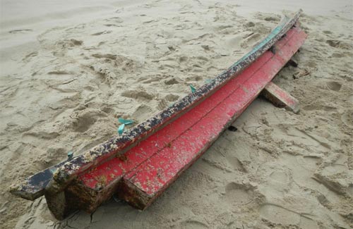
After a 16-foot beam of a Japanese Shinto Shrine washed ashore in Oceanside in March, a very similar 14 foot object has now washed ashore in Florence.  The wooden beam or kasagi appears to be the top part of another Shinto shrine- of which Japan has approximately 80,000- represents a spiritual relic for the Japanese culture.  Even though not all Japanese citizens practice the Shinto religion, Shinto shrines are culturally unique structures that are found in many important natural areas across the country.

The kasagi beam washed ashore near the Siuslaw River this week. The Japanese Consular Office in Portland has been contacted, but the situation will likely be deferred to Jinja Honcho, the Japanese Association of Shinto Shrines.

The 14-food red and black beam as found on a Florence, OR beach. [Photo: beachconnection.net]


Boat Covered in Barnacles Washes Ashore in Crescent City, CA

A 21-foot boat has washed ashore in Crescent City, California, making it one of the first larger objects to wash ashore south of Oregon.  The boat is covered in thousands of pelagic gooseneck barnacles (Lepas anatifera), a common oceanic colonizer, giving it a very odd appearance.

http://i.livescience.com/images/i/000/038/846/original/tsunami_boat.jpg?1365542867
Boat covered in pelagic gooseneck barnacles [Photo: Humboldt State University]
Once some of the barnacles were removed, the Japanese lettering for "Takada High School" was apparent- the high school was in Rikuzentakata City, which was heavily hit by the tsunami. The boat is currently being verified as tsunami debris, but it likely originated from the natural disaster. I will post more information as it is available.

Lettering on the boat, which tied it to a high school affected by the 2011 disaster [Photo: livescience.com]


NOAA Updates Marine Debris GNOME Graphic


Finally, NOAA has updated the GNOME tsanami debris model for the first time since early March.  As larger objects wash ashore on the west coast of North America, the projected critical mass of the debris moves towards US shores.  Click on the map for a larger version on NOAA's webpage.

http://marinedebris.noaa.gov/info/images/gnome_graphic.jpg

Wednesday, January 30, 2013

More debris down the pipeline

Hello all,

In the tradition of keeping my blog post titles as terrible puns, today's post is regarding a giant pipe that has washed up on the Washington shoreline.  Perhaps not the most exciting piece of giant debris that could possibly wash up, it is there nevertheless.

The 19-foot pipe that washed up on a WA state beach on Tuesday. [Photo: KVAL.com]
The pipe was noted by beachgoers on Tuesday, Jan. 29th just below the high tide line at Cape Disappointment (I tried to think of several jokes here...).  It is approximately 19 feet long and 3 feet in diameter.  The pipe is covered in marine species, but the verdict isn't out yet regarding whether there are invasive species or not.  A closer examination of species will allow researchers to better determine the pipe's origin.  As of now, there is not confirmation if this is tsunami debris or not.  More soon!

Another photo of the pipe with a better view of hanging gooseneck barnacles and algae:

Pipe with evident colonized species.  It is not determined whether it includes invasives or not. [Photo: Chinookobserver.com]

-----------------------

British Columbia Littered with Tsunami Debris

The coasts of British Columbia are known for being pristine, secluded, and now, very difficult to clean up.  Recent fly overs by members of West Coast Helicopters have revealed miles of debris along remote shores.   As noted by The Globe and Mail, there appeared to be "garbage scattered on almost every beach for more than 100 kilometres..."  The observer, Peter Barratt, noted that as compared to the past 30 years, there appears to be about 3-4 times more high floating debris, such as large chunks of styrofoam, and 5-10 times the normal amount of small debris.  Mr. Barratt noted that much of the debris appeared to be newer.

West Coast Helicopters plans more in-depth flyovers when the weather improves, and the BC government will likely formulate a cleanup plan for this and other trouble areas.

This brings to mind the fact that styrofoam is one of the most pervasive and detrimental debris types.  Styrofoam does not naturally biodegrade, but instead breaks down into smaller and smaller pieces (much like plastic, mentioned in my last post) which either are consumed by wildlife or work themselves into the environment once they are too small to pick up.

A California beach littered by styrofoam in various degrees of degradation. [Photo: http://www.sanjuancapistrano.org]

Numerous coastal communities have pushed for a styrofoam ban.  To learn a bit more about styrofoam's impacts, as well as potential regulations, check out San Juan Capistrano.org.

If you see styrofoam on a beach and have a means to do so, please pick it up and dispose of it properly.  The bigger the piece the better, as this will slowly degrade over time.  Do a little to make a big difference!

------------------

NOAA: Model Update, 20 Confirmed Cases of Tsunami Debris 
On a brief note, NOAA has reported that they have confirmed 20 of the 1,479 reported debris reports as debris relating to the 2011 tsunamis.

Additionally, NOAA has recently updated its website with a new debris model, formulated as of January 7, 2013.

The new model shows the majority of debris less than 750 miles from the west coast of the US.  Visit NOAA's Debris Model webpage for a better version of the map below.
http://marinedebris.noaa.gov/info/images/gnome_graphic.jpg